Trip task: Transportation to your accommodations
Prerequisites: Accommodation name or address.
Intro
Google Maps is WAY more than just driving directions. In the last lesson, we used an American location as an example, and the Google Maps nearby function led us to some delicious frozen custard. Now we’re going to demonstrate a few options in the actual directions that can make traveling in new countries with different languages a little more approachable. It’s time for a deep dive into Directions to find transportation from the airport to our accommodations.
Using Directions options
We will visit Spain towards the end of the year and stay at the Hotel Indigo Princesa in the heart of downtown Madrid. Unlike the U.S., European hotels rarely offer shuttle service to/from the airport. We could take a taxi, but that would be expensive and wouldn’t get us acquainted with Madrid’s public transportation. 99% of the time, there’s a better option than a taxi.
We first search for directions from Adolfo Suárez Madrid-Barajas Airport to the Hotel Indigo Princesa. However, the public transportation results only show a bus that takes 1 hour and 14 minutes to get to downtown Madrid. That doesn’t seem right.
Step 1: Search for directions from the airport to your accommodations.
The problem: Always notice the time of day next to the results. In this example, the results only show one bus available from the airport to our hotel–and the ride is over an hour! Google is using the time in Madrid right now, not the time we’ll arrive.
The fix: Click on “Leave now” and adjust the time accordingly. We then saw multiple transportation options that were much faster.
These are the results when we run the search again with the approximate time of our arrival at the airport.
Step 2: Look carefully at the details of your chosen transportation option.


The details show exact train times, the number of stops, the name of the stops, and the estimated walk time to our hotel.
Tip: Take note of train or bus lines, the number of stops, and any transfers.
What we would note in our travel document: Take Line 8 for 5 stops to Nuevos Ministerios. Transfer to Line 6 and take it 6 stops to Argüelles.


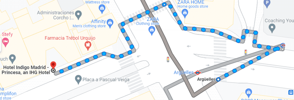
Step 3: Zoom in on the walking portion of the trip to your accommodations.


Click on the little arrow under Walk to see the walking directions.
Summary
Google Maps Directions are a great way to find an efficient and affordable transportation method to get to your accommodations. Specifically, you can see public transportation options like buses and trains. Directions provides vital details like train/bus numbers, schedules, and station names. Then, specific walking directions are displayed that get you exactly where you need to go.


Great Info. Will use on my next trip out of town.
Happy travels! 🙂